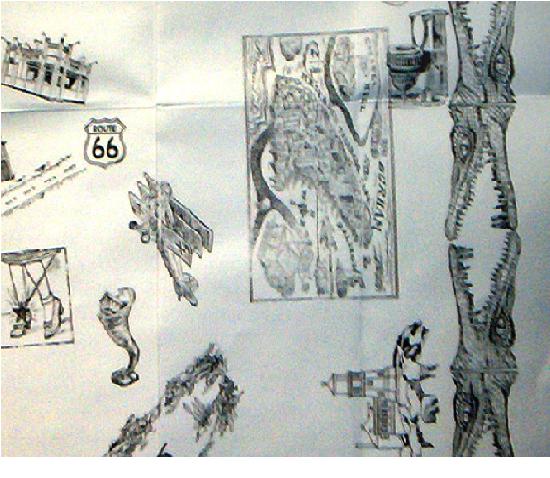
Thursday, November 30, 2006

Mapping the Realm

Carved in the beginning of the 3rd cent. CE, the large marble plan of Rome the Forma Urbis Romae,depicted in astounding detail the ground plan of all architectural features in the ancient city.

The map (measuring ca. 18.10 x 13 meters or ca. 60 x 43 feet) was incised onto marble slabs that hung on a wall of a grand room (aula) in the Templum Pacis in Rome. Time, and the need for marble as a building material, gradually destroyed the Plan. Today, only 1,186 pieces, or 10-15%, of this gargantuan city map exist.

Map page.

The map was remarkably accurate but researchers looking for new sites to excavate in Rome had only managed to fit back together a few of the pieces. A Stanford University computer program is now being used to aid restoration.

The Stanford Digital Forma Urbis Romae Project is now being used to aid restoration. And tries to solve an almost greater puzzle than the Forma Urbis itself - its function. There is no comparative material, literature or inscriptions from antiquity that might shed some light on this problem, nor has the function of the room in the Templum Pacis where the Plan hung, been clearly understood.

Most scholars believe that the aula in which the map hung was the office of the urban prefect, and that the map had a utilitarian purpose, functioning either as a locator map or as a cadastral map (recording land ownership) of Rome. They base their arguments on the incredible detail and accuracy of the map, which must have been the result of real land surveys, and on the scale of 1:240 which is the common scale used in Roman map making.

_ _ _ _ _

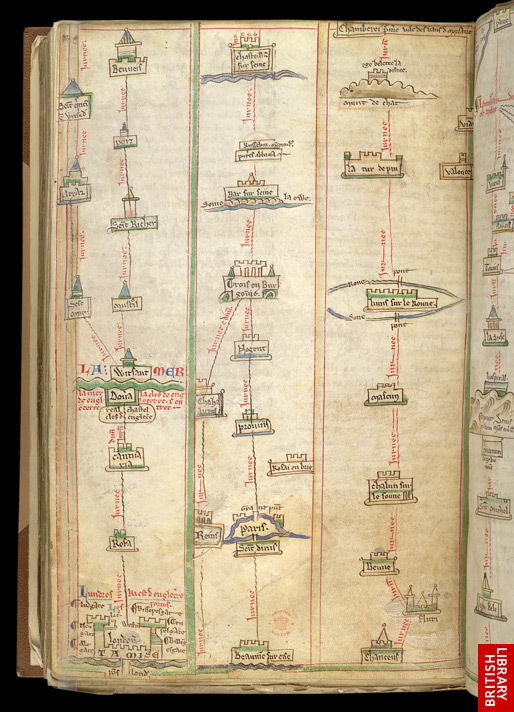
‘Mapping the realm’ is a project funded by the British Academy to create an interactive online version of the celebrated medieval ‘Gough Map’ (also known as The Bodleian Map, is the oldest surviving road map of Great Britain, dating from around 1360.

pen, ink and coloured washes on two skins of vellum, the map's dimensions measure 115 x 56cm.

The identity of the map-maker is unknown, the clues to its accurate dating based on historical changes of place name and studies of the hand used to inscribe those names onto the map.

Although the map is undated, clues are given by certain features, such as the town of Sheppey which changed its name to Queenborough in 1366, but is still marked as Sheppey on the map, whilst paleographic evidence suggests the mid- to late fourteenth century.

The project seeks to find out more about this enigmatic map. Using a scan of the original, undertaken by DigiData Technologies, the Gough Map has been digitised and analysed at the School of Geography at Queen’s using a Geographical Information System (GIS). GIS makes it possible to study the map’s content and assess how it was made, who made it, and what it was made for – all questions yet to be resolved. The map has also been made interactive. via Mapping the Medieval Urban Landscape

Converging Territories

Lalla Essaydi: Converging Territories series

Converging Territories # 9, 200333 1/4 x 40 3/4" chromogenic print

via

Wednesday, November 29, 2006

Processing Problems

Does Art needs to entertain or mainly evoke deep pondering and fundamental questions at the observer's mind, as well as emotional thing etc...? i have no certain answers.

I do know and feel these works by John Kørner (his latest exhibition '2006 Problems'), handed me a vast and colorful range of feeling, first, a sense of sharp humor that made me really laugh...and then came all the (serious) rest of it...couldn't escape feeling his 'conversation' with Dada, Surrealism, but mainly Miro and Dali, (looking at his paintings, it is as if i see the mustache of Dali smiling at me, or, just like the disappearing smile of the Cheshire Cat in Alice in Wonder Land) ...I am in-love with what he makes me see and feel and think :)

John Kørner, 27 Problems, 2006. acrylic on canvas180 x 240 cm

John Kørner does not refer to his works as paintings. He calls them "problems". Naturally there are many different sorts of problems: philosophical, mathematical, homework, riddles. Artist gallery.

John Kørner, Conversation, 2006acrylic on canvas, 180 x 240 cm.

"I could probably write poems. Words have the same capacity as images - they fascinate people and can trigger something." interview with the artist

Music and Problems, 2006, acrylic on canvas260 x 360 cm

Tuesday, November 28, 2006

A-Z London Map

Phyllis Pearsall was a remarkable woman. Born in 1906 she had already lived a rather bohemian life as a writer, painter and traveler when in 1935 she got lost in London while using a 20 year old street map which was at the time the most recent available. Creating the first A-Z atlas was a tough job, Before satellite imaging or extensive aerial photography,working from a bedsit in Horseferry Road and with the aid of James Duncan - a draughtsman borrowed from her father, a Hungarian mapmaker, she began to catalogue the 23,000 streets that featured in the first edition. Working eighteen hour days she walked a total of 3,000 miles of London’s streets. Phyllis Pearsall not only conceived, designed and produced the A-Z street atlas of London, but founded her own company to publish it.

An A-Z map of London's Docklands in 1960 (left) and 2006 (right).

Completed in 1936 she met almost universal apathy from the book buying establishment and so formed the Geographer's A-Z Map Company and arranged to have 10,000 copies printed - completing all the proof-reading and design work herself. She delivered 250 copies to WH Smith (in a wheelbarrow!) on a sale or return basis and it proved a great success - later the formula was extended to other British cities. She rarely thought of the Atlas as anything other than a means to allow her to pursue a life of painting and writing The Geographers' A-Z Map Co, have a website at http://www.atozmaps.co.uk The little book has now become required reading for any Londoner, especially since the number of London streets had risen to 50,000 by the time of her death in 1996. There is now a blue plaque to her memory, in the borough of Southwark; few Londoners deserve that honour more. Maps of London are being devised at this very moment. The story of London, and the map-making of London, will never end.

Traditional method of revision of A-Z mapping at the Geographers' A-Z Map Co. Ltd via newstatesman

encompassing composites

In this series, Idris Khan aggregates the work of renowned artists Bernd and Hilla Becher, famous for their vast photographic collections of buildings and industrial sites.

Idris Khan every. Bernd and Hilla Becher Spherical type Gasholders2004photographic print (framed)208 x 160 cm

"it's obviously not about re-photographing the photographs to make exact copies, but to intervene and bring a spectrum of feelings - warmth, humour, anxiety - to what might otherwise be considered cool aloof image. You can see the illusion of my hand in the layering. It looks like a drawing. It's not systematic or uniform. The opacity of every layer is a different fallible, human decision".

Idris Khan every...Bernd and Hilla Becher Prison type Gasholders 2004photographic print (framed)208 x 160 cm

Idris Khan, every...Bernd and Hilla Becher Gable sided Houses 2004photographic print (framed)208 x 160 cm

Image taken from the saatchi-gallery

Monday, November 27, 2006

Japanese portraits

KENMU (1334-1336) "pictures of the floating world"(ukiyo-e), originated in the metropolitan culture of Edo (Tokyo) during the period of Japanese history, when the political and military power was in the hands of the shoguns, and the country was virtually isolated from the rest of the world. It is an art closely connected with the pleasures of theatres, restaurants, teahouses, geisha and courtesans in the even then very large city. Many ukiyo-e prints by artists like Utamaro and Sharaku were in fact posters, advertising theatre performances and brothels, or idol portraits of popular actors and beautiful teahouse girls.

Kuniyoshi (1797-1861)

Kunisada (1786-1864)

Sadafusa (act ca 1825-1850) via EDO no IKI Gallery , where more magnificent galleries such as this one, or, the artist's KENMU(1334-1336) 'Reflections of the Ages', and many others here, and the amazing woodblock prints of ANDO HIROSHIGE and many many more. As well as a very active message board, and an explanation and exampels of the meaning of Signatures of Ukiyo-e Artists.

want more? try L'estampe japonaise links page!

Mental Map

Franz Ackermann's small-scale mixed-media sketches, which he calls 'mental maps', develop from his wanderings at street level. (Artist's Commentary on Featured Works)

In response to a world that is, for some, more intricately connected than ever, reticular metaphors prevail in contemporary art. Yet the complexities of this world - its financial markets, information and transportation networks, social relations, and so on - exceed figuration and its shifting spaces are opaque to conventional means of representation. In such a situation it is claimed that mapping is no longer a matter of describing the surface of the globe but of reconstructing a scene that has been lived through. This means that cartography comes back down to earth, so to speak. That sovereign power which once surveyed the world from on high, dividing out space, giving measure to it, and more often than not asserting proprietorial and territorial rights over it, is unsustainable: its panoptic eye sees from nowhere, which is, of course, impossible, and the knowledge which it claims of the world is detached, reductive, a fiction.

Franz Ackermann: Untitled (mental map: for security reasons, no water allowed), (Faceland III), 2003, mixed media on paper, 13 x 19 cm: courtesy IMMA

from remote viewing exhibition Franz Ackermann recording about his mental maps works.

Franz Ackermann untitled (mental map: values of the west), (Faceland III), 2003, mixed media on paper, 28 x 29.6 cm

..."The cartographer who comes back to street level, where the air is, for the most part, breathable, immerses him- or herself in specific situations, the topography and horizons of which are set by social conditions to which we are all subjected, not least those of memory and architecture. It is these conditioned and situated experiences that might now provide material for maps. "

Read All

"individuals in a world where traditional geographic hierarchies and borders are in rapid transformation are forced to navigate according to their own experiences" an essey by anna oliver an artist, about maps in the past, present and future, an mainly about representation of maps by artists.

via

Sunday, November 26, 2006

Banned Books

Only last night was watching Fahrenheit 451 Based on the 1951 Ray Bradbury novel of the same name. That tells the story of Guy Montag, a firefighter who lives in a lonely, isolated society where books have been outlawed by a government fearing an independent-thinking public.

It is the duty of firefighters to burn any books on sight or said collections that have been reported by informants.

And today found details about an exhibition of books which have survived Fire, the Sword and the Censors

via Plep

Thomas Hobbes. Leviathan, 1651.* The copy which belonged to the Scottish patriot Andrew Fletcher of Saltoun with his signature on the engraved title. Fletcher's own Defence of the Scots Settlement at Darien, 1699, was burned.

Old Enough To Be My Mother

Nathan Ritterpusch, Old Enough To Be My Mother #43, 2006, Oil on canvas 14 X 12"

more about your artist at Rare-Gallery

Saturday, November 25, 2006

Forbidden City

"I wandered in S&M and swingers clubs in New York and Paris, pursuing a dream of dissolution, harmony and collective ecstasy. My hidden camera was my own perversion, my littlesubliminating machine. " Jean-Christian Bourcart

Forbidden CityNew York - Paris, 1998-2001

check his Traffic series, and his Stardust series

some sweet day

The Work of Darlene Cole:

some sweet day (don't forget you're young) 2006 oil on canvas 14 x 11 in.

Mermaid Box

"Mermaid Box"(Maryland) Glass, oil painting and found object. 3.5 x 3 x 3.5 inches

by Carmen Lozar

The Dada Millennium Map of the United States

The Dada Millennium Map of the United States, 1999 (by Dr. David "Jim" Nemeth )

as appeard at the The California Geographer (1999, Volume 39 )

"What might be the outcome of bending the traditional rules of cartography in favor of chance? Our answer is "something Dada." What does chance have to do with cartography and Dada? Taking the last first, Dada is a recent expression of the ancient absurdist spirit of relativism which, as an antidote to rationalism... As a protest movement against the excesses of a rational society, Dada mushroomed briefly in the immediate aftermath of the First World War. It arose among French and German intellectuals out of their sheer moral exhaustion and nausea over that War."

Dr Nemeth and Dr Kaplan, Department of Geography and Planning University of Toledo

Dada was more generally a protest against the hypocritical values of an arrogant self-satisfied world that preached aesthetics and progressive thoughts while squandering life.

map detail

map detail

"the text and images constitute a critique of socio-economic and environmental conditions across the United States on the threshold of the second millennium. The deliberate irrationality of our Dada map negates the laws of beauty and organization in traditional mapping. Designed to be mailed instead of filed, framed or referenced, our absurdist cartography partakes in an interdisciplinary, international, and largely underground correspondence art movement whose members most likely would be amused instead of outraged by the emergence of an anti- or parallel cartography. And, as a mailed item, our Dada map "corresponds" to the world in an ambiguous sense of the word, by refusing to correspond to the Establishment's traditional perceptions of what constitutes an acceptable representation of the real, or a cartographic truth. In its typography, layout and philosophy, the Dada Millennium Map of the United States defiantly violates all the conventions of good taste in cartographic publishing. In conclusion, we began by asking "What might be the outcome of bending the traditional rules of cartography in favor of chance?" One outcome is our Dada Map, a product of an alternative cartography that is appropriate to serving—not another War Machine—but serving as everyone's own doormap to the end of the millenium. Look to your mailbox soon for the Dada Millennium Map. Unfold it. Behold it. Wipe your feet on it."

map detail

Friday, November 24, 2006

London: A Life in Google Maps

By reading the fascinating article City of illusions by Peter Ackroyd, i leared about this exhibition

(via 3 quark daily):

A virtual exhibition Google Map "London: a life in maps" opens at the British Library, London NW1 on the 24 November. For details, see [http://www.bl.uk/]

London: A Life in Maps charts the growth of the city by looking at maps of it through the ages. The exhibition is broken down into seven themes, each broadly covering a different period in the city's history. by going over present London google map, one is invited to travel over time and maps.

John Ogilby, ROAD MAPS. London, Ewell, Dorking, Billingshurst, Amberley, Arundel, Chichester

An Exact Surveigh of the Streets, Lanes and Churches Comprehend Within the Ruins of the City of London, 1723

London was founded by the Romans in about 50 AD and acquired its walls between 190 and 225. Despite some expansion London remained essentially within these walls until 1550. The city had several generally-accepted set images at this time – particularly as a walled city and as a city on the Thames - before the creation of the standard view from Bankside dating from the 1540s. William Smith's 1588 panorama for example remains an iconic image of London. The earliest surviving printed maps of London portray a bustling, prosperous and well-ordered city. Wenceslas Hollar was completing what would have been a magnificent map when the Great Fire of 1666 intervened. But in reality there had always been more industry (and noise, discomfort, disease and smells) than was reflected in the printed maps.

Itinerary From London To Chambery, In Matthew Paris's 'Book Of Additions' 1250-1254

The history of London may be said to unfold, map by map, in symbolic fashion. The map is a symbol, not a record or a description. It bears as much relation to the actual shape and nature of London as the sculptures of Canova or Rodin bear to the human form. The map is an idealisation, a beautiful illusion of symmetry and grace. It gives form and order to the formless and disordered appearance of the capital.

The first printed map of London has been called the "Agas map" but in fact its designer and engraver are unknown; it is believed to have been commissioned by Queen Mary to celebrate the 16th-century city over which she ruled. In its complete form, it would have measured some eight feet wide and five feet high, and was designed to encompass both the city and its suburbs beyond the walls.

a section of the Agas map

read article

Thursday, November 23, 2006

nameless

Many of the work of Jindřich Štreit were taken in Czechoslovakia before 1989.

Křížov, Czech Republic, 1982

via new-art

Electronic Graphics

In the early 1960s digital computers became available to artists for the first time(although they cost from $100.000 to several millions, required air conditioning, and thereforelocated in separate computer rooms, uninhabitable 'studios';programs and data had to be prepared with the keypunch, punch cards then fed into the computer;systems were not interactive and could produce only still images).

The output medium was usually a pen plotter, microfilm plotter (hybrid bwn vector CRT and a raster image device), line printer or an alphanumeric printout, which was then manually transferred into a visual medium. read all

Herbert Franke (1927, de): Lichtformen, 1953-55:

Herbert Franke's wide-ranging interests include the use of random-number generators, image-processing, numerically-controlled machine tools, iterative techniques, fractals and even a series of experiments with music produced on the self-constructed wind instrumentof colleague Bruno Spoerri.

Now day many programs are avialable for people who want to program images, animation, and sound. program such as Processing: an open source programming language and environment

It is used by students, artists, designers, architects, researchers, and hobbyists for learning, prototyping, and production. It is created to teach fundamentals of computer programming within a visual context and to serve as a software sketchbook and professional production tool. Processing is developed by artists and designers as an alternative to proprietary software tools in the same domain. view Processing Flickr album

The EDSVJ project is driven by human heart: The instalation itself is using multiple inputs influencing algorythm parametres determinating the basic outlines of the final videosequence that can be seen. The experiment is technology-wise based on real-time inputs and proce55ing software. "this experiment is based on mine understanding of computer humanization.">>

Oxymorons

Peace force

Silent scream

Strangely familiar

Soft rock

Sweet sorrow

Christian scientists

Act naturally

Found missing

Same difference

Alone together

Until then

Sure bet

see as well Crazy & Mad, Quiet Thoughts, and all the others (links at the bottom of page)

Empty Signs

Nathan Abels. "Empty Signs" acrylic on panel by Nathan Abels.

With bare bulbs against the backgound of an empty sky, Abels sees these frames as "symbols of uncertainty."

some other works by the artist, i can relate to:

view gallery

Literary New York Map

Novelist Paul Auster writes in "The New York Trilogy: "New York was an inexhaustible space, a labyrinth of endless steps, and no matter how far he walked, no matter how well he came to know its neighborhoods and streets, it always left him with the feeling of being lost."

This article propose to plan a vacation based solely around literary New York - to eat at the same restaurants, stay in the same hotels, explore the same city as a beloved fictional character. This journey may reveal a fresh glimpse of a city that is, tantalizingly, never fully knowable.

photo: Copyright 2006 The New York Times Company

and you can visit the Literary map of Manhattan

via

Tuesday, November 21, 2006

Last Supper on Toast

"Last Supper on Toast"2004approx. 4" x 6½" (10.1 x 16.5 cm)~ Whole wheat

This remarkable instance of a haphazard pattern appearing to represent a recognizable person or scene was discovered by Hubert R Portnoise of East Camden, New Jersey, who describes the incident in this transcript of an interview with Bob Abercrombie from Camden Places & Faces, WRBX-TV, Channel 89, November 7, 2004:

WRBX-TV: "So, how did you come to discover this rare... uh, find, Mr Portnoise?

MR PORTNOISE: "Can you hear me okay through this?"

WRBX-TV: "Yes, the audio is coming through loud and clear according to our engineer."

MR PORTNOISE: "Well, okay then.... it's kind of tiny for a microphone, though.... Anyway, this happened on May 23rd this year. That was a Sunday, and, like I do every Sunday morning, I fetch the paper from the porch and I bring it to the kitchen table while I wait for the wife— that's Mrs Portnoise— to get around to making breakfast. So I'm sitting there reading about how the Red Sox are going to get creamed again this year as usual- that's pretty funny when you think about it, I mean after the Series and all- when the old lady puts the scrambled eggs and bacon on top of the part I was reading like she always does, and of course she forgets the toast. Thirty-four years we been married, she still forgets the toast! You married?"

WRBX-TV: "I'm not married, no."

MR PORTNOISE: "Smart move. You got a girlfriend, then?"

WRBX-TV: "Ah, not a girlfriend, no."

MR PORTNOISE: "So you don't know how you just don’t serve a man his scrambled eggs and bacon without you give him his toast, right? I mean, now I got to wait for the toast to be made, and by that time the bacon and eggs are cold. So I'm pissed off, like usual— can I say pissed on TV?"

WRBX-TV: "Uh... I guess you just have!" (nervous laughter)

MR PORTNOISE: "Okay, so I'm pissed off as usual because I have to eat the toast after the bacon and eggs or they go cold, right? Then I see she used the old Sunbeam toaster again, instead of that fancy-shmancy Cuisinart my brother-in-law sent us last Xmas. He's no good, but that toaster makes terrific toast. The Sunbeam ain't for shi- I mean, the Sunbeam, it leaves the bottom and the sides of the bread raw, like you can see in the picture here. So then I'm really pissed, and I pick up the butter, and guess what? It's hard as a rock! How you supposed to spread butter on a piece of toast if it's frozen solid? She knows how I hate hard butter! I mean, if I put the frozen butter pat on the toast it just lays there, cooling off the toast. By the time the butter starts melting, the toast is stone cold! So I'm sitting there, pissed as hell, wondering if I should nuke the butter so's it can melt, except I don't want to give her the satisfaction, so I'm just staring at it, and that's when I see what looks like a picture burnt into the toast! Now, I always get a laugh out of these kooks who are all the time finding faces of God and saints and stuff on food, but this is the real article! I mean, it reminded me of that picture by Leonardo DiCaprio, you know, the Last something or whatever."

WRBX-TV: "Uh, that's da Vinci and the Last Supper."

MR PORTNOISE: "You got it. And then I take it to the window and pull back those ugly curtains she insists on hanging there even though it makes the kitchen so dark I have to sometimes leave the refrigerator door open just to find my way around... I take it to the window and sure enough, it looks just like the one that dago painter did!"

WRBX-TV: "Uh..."

MR PORTNOISE: "Then I'm thinking to myself- hey, there are people who pay big time for this kind of thing. Some casino down in Atlantic City or Vegas dropped a couple of grand on that dame who had the cheese sandwich that looked like Jean Harlow."

WRBX-TV: "I believe the claim was that it looked like Mary, the Mother of God."

MR PORTNOISE: "Oh yeah? To me it was a dead ringer for Jean Harlow. That's funny. Anyway, right off the bat it hits me that if this thing is worth some bucks, how am I going to keep it away from old nosy-britches- that's Mrs Portnoise, to you. So the first thing I do, I pop it in a baggie and I put it way in the back of the freezer, next to the remains of that meat loaf she made in 1986 that nobody is ever going to touch again."

WRBX-TV: "1986?" (weakly)

MR PORTNOISE: "You should see the shi- the stuff she's got in there! I tell her if it was bad the first time around, there ain't going to be a second time- no way! But does she toss it? No! Some of the stuff in there, the writing on the label has worn off- it could be anything! But does she toss it? No!

WRBX-TV: "I'm sorry to interrupt, MR PORTNOISE, but we're running out of time on this segment of Camden Places & Faces. We certainly appreciate your- "

MR PORTNOISE: "You don't want to hear how her and that shyster lawyer screwed me out of the money I was supposed to get from the casino?"

WRBX-TV: "Not today, no. Perhaps another segment of Camden Places & Faces. We'll be in touch. Thank you, Hubert R Portnoise of East Camden, New Jersey, for your fascinating account of what we in the media game have come to call the Host on the Toast. And, speaking of hosts, this is yours, Bob Abercrombie, for Camden Places & Faces, here on WRBX-TV, Greater Camden's Neighborhood Channel. Now back to Belinda with Neighborhood News.

MR PORTNOISE: "I mean, you talk about your rip-offs! She..."

-- END

--Donation to the Gallery of the Unidentifiable made possible by conditions in the household effects settlement of Portnoise vs Portnoise #05-8831, Camden Civil Court, Camden, New Jersey. Transcript courtesy of WRBX-TV.

via Gladys Dwindlebimmers Ralston Gallery of the Unidentifiable ~ Fair and Balanced

gentlemen's pocket globes

Georgian gentlemen with these elegant pocket globes, one celestial and one terrestrial, crafted of fine hardwoods by Newton and Son (London, 1820).

Pocket globes as viewed here were produced beginning in the latter half of the eighteenth century, and were often crafted of wood, ivory, and papier-mache. They relied on the engraver's art for the maps themselves. Cases were often made of fishskin and lined with celestial gores, in the case of terrestrial globes. I have yet to find one not of English manufacture.

For those eager for more detail on the object and phenomenon itself, antique dealer George Glazer writes of Newton: "In 1783, John Newton launched his globe making business with the first versions of this pocket globe and case, one co-published with the engraver William Palmer (fl. 1765-1803) and soon thereafter, one under his own imprint. Newton had apprenticed with Thomas Bateman, successor to Nathaniel Hill, and utilized the plates of Hill's 1754 pocket globe, adding recent discoveries by Captain Cook." via the great blog: Dream Tree

DropSpot Map

A dropspot is a kind of alternative mailbox. It’s a hiding place in a public space, where people can leave things for exchange... Go to Drop Spots, and put your drop spot on the map.

via new-art.blogspot

map of Israel

By DUDU GEVA

Monday, November 20, 2006

Unpacking the Boîte-en-valise

Assembled between 1935-41, Boîte-en-valise is a "traveling museum" of 69 works by Marcel Duchamp that include Fountain, Large Glass, Broyeuse de chocolat, Why Not Sneeze Rose Sélavy, Tu m', Paris Air, Pliant de voyage, 3 Stoppages Etalon, Bride, Comb, and others.

Duchamp's aim was "to reproduce the paintings and the objects he liked and collect them in a space as small as possible."

Marcel Duchamp, miniature reproduction of Fountain (1917), in Boîte-en-Valise (1935-41)

If the readymade is that object which should be "a work without an artist to make it," the objects in the Boîte-en-valise upset the concept of the readymade by their quality of being remade readymades....

via Unpacking the Boîte-en-valise: Playing off Duchampian Deferral and Derrida's "différance" by Lam, Yishan at the toutfait-Marcel Duchamp Online Journal

To me, "box works" manifest the other side of mapping, or is it just the same urge? The American artist Mark Dion has just completed a period as artist-in-residence with the AHRC Surrealism Centre. Renowned internationally for his museum-based interventions, Dion’s residency culminated in the creation of a mock bureau(See the slideshow) for surrealist research within the Manchester Museum. Sifting through the Museum’s rich collections with an eye for the strange and unclassifiable, Dion has created a fantastic ambiance that is surrealist in spirit and that evokes, in the manner of a cabinet of curiosity, their passion for collecting objects, both natural and man-made. The bureau will remain in situ for at least 18 months. An artist’s book by Mark Dion that accompanies the installation has been published by Bookworks and is available for purchase. via thingsmagazine

All this took me back to Joseph Cornell project: boxing the universe, who takes images and ideas from the realm of science, and makes us wonder what was the concepts that may have tied them together in his mind. By examining Cornell's selection of materials and the way he has put them together, one can infer--that is, reconstruct--his cosmology "

Untitled (Soap Bubble Set)1936Construction15 3/4 x 14 1/4 x 5 7/16 in.Wadsworth Atheneum, Hartford, CT Cornell "was making small voyages of discovery, scavenging for relics of the past in New York junk shops and flea markets. To others, these deposits might be refuse, but to Cornell they were the strata of repressed memory, a jumble of elements waiting to be grafted and mated to one another...In the studio he would sort his finds into their eccentric categories - 'Spiders,' 'Moons,' and so forth - and file them with boxes of his own mementos...and from them he made boxes.

JOSEPH CORNELL Untitled (Solar Set)c. 1956-58Construction11 1/2 x 16 1/4 x 3 5/8 in.Collection Donald Karshan, New York

Object (Roses des Vents)1942-1953Construction2 5/8 x 21 1/4 x 10 3/8 in.The Museum of Modern Art, New York

Object (Roses des Vents)

begun in 1942 and not finished until 1953. It is full of emblems of voyages Cornell never took, a little box of mummified waves and shrunken exotic coasts, peninsulas, planets, things set in compartments, with a drop-in panel containing twenty-one compasses, each with its needle pointing insouciantly in a different direction from that of its neighbor. Even the map on the inside of the lid, cut from some nineteenth-century German chart book, depicts an excessively remote coastline: that of the Great Australian Bight. The earth is presented not as our daily habitat but as one strange planet among others, which to Cornell it was.

Untitled (Medici Princess)c. 1948Construction17 5/8 x 11 1/8 x 4 3/8 in.Private collection

more beautiful works by Cornell

sea maps

"Atlas de la navigation" In Atlas de la Navigation et du Commerce, edited by Louis Renard - A huge collection of beautiful maps see and more and much more...

The Pacific, With California as an Island

via Ryhiner Collection

One Man City

ZHONG BIAO, Insomnia, charcoal and acrylic on canvas 2004

ZHONG BIAO, Friends, charcoal and acrylic on canvas 2004

Propaganda map

Sex and Propaganda

Japanese propaganda caricature map from around 1941, depicting a U.S. blockade of Japan from the Philippines (then a U.S. possession) via

Serio-Comique Map of Europe at War (London, 1914)Maps 200 HKM 1914. Map Collection

via