Maya Bloch
Israeli artist Maya Bloch is the most wonderful, gifted artist of Thierry Goldberg Projects, New York, soon to have her 3RD solo exhibition at the Gallery.

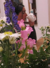
Untitled, 2011 acrylic on canvas, 150 x 120cm
Israeli artist Maya Bloch is the most wonderful, gifted artist of Thierry Goldberg Projects, New York, soon to have her 3RD solo exhibition at the Gallery.
Untitled, 2011 acrylic on canvas, 150 x 120cm
PLAN OF THE CITY from Joshua Frankel on Vimeo.
Plan of the City is a new animated film, conceived and directed by Joshua Frankel, about the architecture of New York City blasting off into outer space and resettling on Mars. The film's visuals are an animated collage combining live action footage, animated elements, illustrations and treated photographs, including photos taken by the Mars rovers Spirit and Opportunity made available to the public domain by the NASA Jet Propulsion Laboratory. Plan of the City was created in collaboration with composer Judd Greenstein and NOW Ensemble, an acclaimed "indie classical" chamber ensemble; the ensemble, including Greenstein, feature prominently in the film as live actors set inside the animated framework.
this google map allows to explore New York City's street-art scene, from works by Banksy, Keith Haring, Swoon, Shepard Fairey, Os Gemeos, Invader, Dash Snow, and others. the project was made by ArtWeLove.

via http://www.artwelove.com/. and via briansholis and 16miles

Astroland Coney Island, 2007oil on linen48 x 54”

New York Harbor from Above Brooklyn, 2007oil on linen60 x 66”

A year record of walking and biking in New York City. {these maps were not made with GPS } made by fakeisthenewreal (check his other infographic projects)

An other eclectic collection of maps {and 'desk cleaning'}.
This picture is a visualisation of the entire tree of life (of a cellular organisms)

via greatmap
#
The artist Kathy Prendergast -body map(Unfortunately i have found only one of her body maps for now)

via maphist
Minnesota Road Atlas XXIII is made also by Kathy Prendergast

Works on Paper (Drawings, Watercolors etc.) ink on printed paper 2005
###
Personal pies (self-examination/pie charts, 2007) is an other cool project by Craig Robinson

via serifpublishing
####
The "Gran Manila"- Manila and its districts. 1884.

From A site devoted to Discovering the Philippines
######
Lordy Rodriguez: New States
#######
New York and Environs.

New York and Environs. 1859 John Bachman. American lithographic firm, 1849–79. Color lithograph more at the NYPL Digital Gllery:
Birdseye View of Central Park - John Bachman - 1859:

via personism
#######
Historical Tsunami Travel Time Maps

########
Fictitious southern continent

Map of a made-up southern continent, late 1500s via The British Library - Deception, lies, and made-up lands
#########
The Unveiling of Britain -from one of my favorites selection of maps (823 items) shows "views that traces the growing awareness of the form of British Isles and their place in the wider world during the years between 800 and 1600".

Plan of Brighton under Attack. Ink and tempera on parchment, 45x78 centimetres

A drawing of Calshot Castle near Weymouth, Dorset, dating from 1539

A Plan of Aymouth, or Eyemouth, [Berwickshire] taken in 1557, in which year it was fortified by Henri Clutin, Sieur d'Oysell et de Ville Parisis

A Coloured View of the North Cliffs, Dover, Showing the "Bulwerck in the Clyff", around 1541

The Bohemian Index is determined as follows: [(% of persons 18–24 with some college or associate degree or higher) + 7(% of persons 25+ with a bachelors degree or higher)] / [median household income in dollars] (Data: 2000 U.S. Census)

Manhattan: Bohemian tendencies are seen circling outward from NYU and Columbia, occupying select areas nearby (notably not Harlem or East Harlem, which offer a distinct drop in bohemian-ness from contiguous Morningside Heights).
The building of New York’s bridges, photographed by Eugene de Salignac.
from The New Yorker

Painters on the cables of the Brooklyn Bridge, October 7, 1914
De Salignac, had worked for the Department of Bridges (later the Department of Plant and Structures) from 1903 to 1934. Vast reaches of infrastructure were laid down in those years, and his job was to provide a record: he shot the construction of the Manhattan and Queensboro Bridges and the Municipal Building; subway tunnels, trolley lines, and ferries.
For the next few days, i'll be posting an on-going post, of an eclectic accumulation of maps, all sorts of maps...lets us begin:
People Make the World Go Round by artist EDUARDO SARABIA

People Make the World Go Round (view detail), 2003Gouache on paper48 x 73 inches, 122 x 185 cm

180 x 120 x 2 centimetres, Detail of map of the world, made with tea stain on dress making pattern with dress making pins. paper; dress making patterns; tea
I love kottke map findings, from his 'map drawn by memory' which is a real treasure: this one is 4ojos from his flick map album:

historic cities maps - This site is a joint project of the Historic Cities Center of the Department of Geography, the Hebrew University of Jerusalem and the Jewish National and University Library.

Map of Basel, 1575, Braun and Hogenberg
An Eighteenth Century Chinese 'wheelmap' of the world (via

Click to
Thematic maps - Milestones in the History of Thematic Cartography, Statistical Graphics, and Data Visualization

Johann Heinrich Lambert's Farbenpyramide 1758-1772 via
Many Atlases of New York city from the digitalgallery.nypl:

G.W. Bromley & Co. --
Diving in this Map Paradise again 1906 Schottische Inseln Scottish islands

works by Riccardo Gusmaroli

untitled, 2004, 70 x 120 cm

Senza titolo, 2002, Work on Paper w/map, 125.5 x 138 cm.

Came across by Howard Horowitz, 1997 Manhattan WordMap some time last February ...
This “wordmap” is both a poem and a map. It took the author, a poet and professor of geography at Ramapo College, a year and a half to design this poem about the city, its geography, cultural attractions, buildings, institutions, individuals, and his own personal memories.

and found it back in greatmap this week.
A mud map is a map a farmer draws on the ground for a passing traveler.
It is rough and ready, not very detailed, and lacks nuance. The scale may be inaccurate, but the map has the details needed for the journey.

Working with only a biro and a camera, and with no knowledge of the area, Hugh Davies representing Analogue Art Map spent the 2006 Conflux Festival seeking hand drawn maps from locals in the Brooklyn NY area, he was navigating Brooklyn for two days using only maps drawn by Brooklynites upon request for directions.
These maps gave directions to sources of food, water and rest as well as to possible points of interest. Ultimately, the maps are psychological map of the Brooklyn landscapes resources, traditions and stories from the point of view of how locals understand it, as well as how they believe visitors might best experience and interpret it. read as well the Mud Map Theology


