GPS maps
Global Positioning System - GPS Drawing Digital mark-making with satellite navigation technology an on going project by Jeremy Wood
"The work is rooted in an interest in the processes and methodologies in the field of drawing. GPS drawings are exhibited as printed editions and sculptures as part of ongoing research into writing over the earth and drawing with ourselves as we move....The GPS maps are part of ongoing research into personal cartography.
The idea of using GPS as a tool to draw with grew from recording the holding-pattern of a commercial airline flight from Berlin to London in October 2000. It has since been developed to incorporate the recording of all my trajectories as a digital trail. Recent work includes the presentation of my tracks as cartographic journals in a study of my movements over the past few years." read more, and makingmaps as well.

"...The raw GPS data is the material for digital and physical representation. The drawing takes place as and when one is being recorded by the GPS. We draw with ourselves as we move and map our experiences along the way...The project considers our travels, from the trivial and the routine, via the special and the ordeal. The ways in which we approach and treat our travels can reveal a great deal about us. The qualities of our tracks, like the traces drawn by a pen, are determined by our movements and expressions. "
The GPS maps were made to measure travels and tracks and the experiments show results from unscrupulous tests.
Here are some of the experiments shown at the site:
Hackney Football

Location: Hackney Marsh, London, UK. Track Length: 18.6 km Each football pitch takes aproximatley twelve minutes to trace around the chalk markings with a single line.
 Location: Trap Grounds in Oxford
The purpose of this commission was to calculate the accessible area of the Trap Grounds in Oxford. A map was produced by walking around the six acre site with hand-held GPS receivers.
Amongst the GPS tracks found on the site are the tracings of historic and geographic features on foot, algorithmic plotting, crosshatching on a lawnmower, paddleboat doodling, and scribbling in the sky.
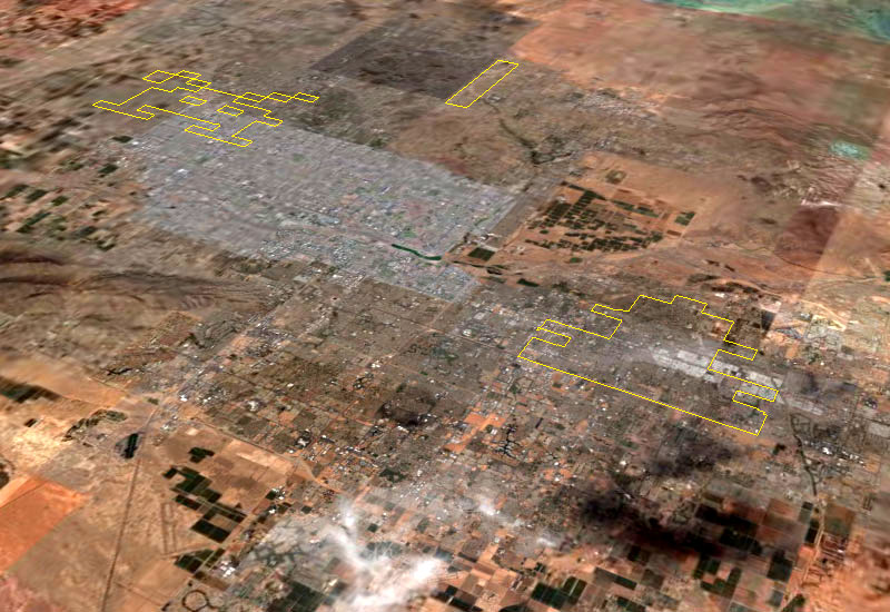
"The GPS maps are part of ongoing research into personal cartography. I record most of my movements with GPS and compile them to create visual journals. The ways around my routine routes have become increasingly elaborate." jeremy wood Phoenix Space Invaders Arizona, USA. 01/2006The drawing below is of the final moments of a game of Atari Space Invaders. It was made over two days and is composed of 100 miles of GPS tracks recorded in a rented car.
Download Google Earth File from Google Earth Community
View more


1 comment:
Since I get GPS I became a more happy and relaxed way, I love on weekends to travel outside the city to any forest or whatever, this is so helpful, I already lost myself in a couple of occasions.
Post a Comment