Showing posts with label History. Show all posts

Saturday, May 01, 2010

Cartographies of Time

New book about the history of graphic representations of time, 'Cartographies of Time - A History of the Timeline', by Daniel Rosenberg and Anthony Grafton, writes about the subjects while handing us some rare and beautiful maps, charts and diagrams.

'Spiegazione della Carta Istorica dell'Italia' (Historical map of Italy) by Girolamo Andrea Martignoni

*

Edward Quin’s 1828 “Historical Atlas” used a series of maps to show changes in the world’s political divisions. In successive maps, the clouds roll back to reveal how much of the world was known to the West at the time. The map at left shows the state of the West at the time of the death of Emperor Constantine, in 337.

via Bibliodyssey

Tuesday, January 19, 2010

LUNNA

The Jewish settlement in Grodno area most likely began in the 14th century when Belarus was part of the Litevanian monarchy. In 1569, as a result of a confederation between Poland and the Lithuania, Belarus (including the Grodno region) became part of Poland. In the period between 1569 and 1795, as a result of commerce in Grodno, Jews settled in the vicinity and developed well organized communities. During the 16th century the two small villages of Lunna and Wola (also spelled as: Wolla, Wolya and Wolie) were established on a typical agricultural plane surrounded on the east and south by mild hills.

The 1900 map of Lunna (the only existing detailed map) illustrates the center of the town as a circled square surrounded by residential and religious buildings. The Pravoslavic (Russian Orthodox) Church was located in the middle of the square. East of the church stood two synagogues (marked by two zodiac symbols). Nearby, there was a catholic church. The map also shows roads leading from the center of the town in four directions. Along the South-East road leading to Wolpa (11.4 kilometers) were the houses of Wola surrounded by small farms and a mansion (marked with a symbol G. db-Grazdansky Dvor) and a forest. The road toward the North crossed the Niemen River via a bridge and led to Skidel (15 kilometers). There were brick factories (marked by two symbols of Krip) at the North-West direction. At the South-West direction, there was a stream (marked as Wodotok). There were five cemeteries (marked by Ki - Kladbiszcze); two Christian cemeteries (marked by a cross), and three Jewish cemeteries located South-West to the Niemen River (the "old" and "new" cemeteries of Lunna and the cemetery of Wola.)

Tuesday, October 27, 2009

Look at the World

from FORTUNE magazine archive - MAPS, beautiful collection of maps dated from the 2ed world war period till the 60's

SYNTHETICA an invented land, October 1940 the relationship between the synthetic substances

THE LAND AS WE USE IT , June 1943 Richard Lindner

a great section for illustrations such as this via strangemaps and portent

Sunday, September 06, 2009

Night Over Europe

The following press clipping is on the back of the photograph: Night Over Europe Enemy tracer bullets weave an intricate pattern as they shoot towards the planes of the Royal Air Force during a night attack on Hamburg. This picture was made from one of the raiding planes. via unpalombaro and we are sick

Monday, July 21, 2008

Indian "Ledger"

The images are taken from a site that is dedicated to presenting and and preserving Plains art, drawings on paper, from the late 19th century for research and enjoyment.

One of the most beautiful albums:

Plains Indian Ledger Art.Native American art in ... accounting ledgers.'Beginning in the early 1860s, Plains Indian men adapted their representational style of painting to paper in the form of accountants ledger books. Traditional paints and bone and stick brushes used to paint on hide gave way to new implements such as colored pencils, crayon, and occasionally water color paints. Plains artists acquired paper and new drawing materials in trade, or as booty after a military engagement, or from a raid...' via plep

Friday, April 25, 2008

an outside map (view) of Ulleungdo

The following map was made by Lee Gyu-won after his inspection of Ulleungdo in 1882. The name of the map is “Ulleungdo Woido”, and essentially means “an outside map (view) of Ulleungdo.” In other words, the map focuses on the shoreline and neighboring islands, islets, and rocks. Notice how the mountain peaks slant inward, which suggests that you are viewing them from the “outside.” read on

Wednesday, January 30, 2008

Visualizing the Bible

Interesting Visualizing the Bible project by Chris Harrison is a sort of a biblical social network.

Distribution of Biblical People and Places (detail view)

via kottke

Tuesday, January 15, 2008

Antonio Pigafetta (c. 1491 – c. 1534), was an Italian navigator. He paid a large sum of money to accompany and assist the Portuguese captain Ferdinand Magellan and his Spanish crew on their trip around the world. During the voyage, he kept an accurate journal.

Thursday, August 16, 2007

island book

Maps by Millo Antonio From an isolario (island book) of the Mediterranea... and many of them are Greek Islands, my new passion

[Lesbos and the adjacent coast of Asia Minor] 1590

Antonio Millo, 1590 manuscript Bound sheet. Ms. 31 x 20.5cm

Antonio Millo island of Andri, 1590

Wednesday, July 04, 2007

Protesting Cartography or Places the United States has Bombed. Project (1998 - 2005) by elin o’Hara slavick.

"These drawings are manifestations of self-education on the subjects of U.S. military interventions, geography, politics, history, cartography, and the language of war...The drawings are also a means to educate others. I make them beautiful to seduce the viewer so that she will take a closer look, read the accompanying information that explains the horror beneath the surface." inspiration and information sais the artist is from many sources, but especially from William Blum’s book, Killing Hope – U.S. Military and CIA Interventions since W.W.II.

Laos, (L'Armee Clandestine), Between 1965-1973, more than 2 million tons of bombs rained down upon the people of Laos, more than the U.S. had dropped on both Germany and Japan in WWII.

Pakistan, August 21, 1998,

Hypocenter in Hiroshima, 1945

Shifa Pharmaceutical Plant, Sudan, August 20, 1998, "U.S. Military Strike on a Chemical Weapons Plant"

via criticalspatialpractice

Tuesday, June 05, 2007

For the Love of God

Damien Hirst's diamond skull is a life-size cast of a human skull in platinum, covered entirely by 8,601 VVS to flawless pavé-set diamonds, weighing a total of 1,106.18 carats.

Hirst continues to explore the fundamental themes of human existence – life, death, truth, love, immortality and art itself. Hirst is pushing a concept known so it seems since ancient times:

It did remind me of the Jericho skulls. Jericho is the oldest known city, 8500-7500 BC. and only in the 50's, a huge discovery was Jericho's plastered skulls - it was a replications of the deceased sculpted onto the skull. It was an ancestor-worship. The residents of Jericho buried dead family members under floor of household.

Damien Hirst. For the Love of God 2007 Platinum, diamonds and human teeth6 3/4 x 5 x 7 1/2 in. (17.1 x 12.7 x 19.1 cm)

‘The skull is out of this world, celestial almost’ writes the distinguished art historian Rudi Fuchs. ‘It proclaims victory over decay. At the same time’, Fuchs continues, ‘it represents death as something infinitely more relentless. Compared to the tearful sadness of a vanitas scene, the diamond skull is glory itself’. read more

This skull from the site of ancient Jericho is covered with molded plaster and has eyes of shell.

via thingsmagazine

World's Oldest Map

"Maps are older than writing and are possibly older than language" it is explained by the simple fact that "given the importance of spatial location to survival, it seems reasonable that early humans would find some way to physically embody the maps stored between their ears. "

But This article discusses mainly the candidates for the world’s oldest map and the criteria involved: what makes a map a map and not a painting.

via maproom

Saturday, May 26, 2007

maps in illuminated manuscript

The British Library Catalogue of Illuminated Manuscripts has some beautiful maps illustrations.

from Christophoro Buondelmonti- Liber insularum archipelagi 1482

Ptolemaic maps added to the Geographia on inserted leaves Eastern Mediterranean; between 1425 and 1499:

John Hardyng Chronicle of Britian to Henry VI

Monday, April 23, 2007

The Geography of Artemidoros

A section of the first-century-BC Papyrus of Artemidorus is shown in this photo. The parchment was the work of an Egyptian copyist - who transcribed books by Greek geographer Artemidorus - and a painter who inserted drawings of maps.

Read more and here

Papyrus Reveals Ancient Stories

X

Artemidorus wrote an eleven book geography in Greek in the 1st century BC, based on his travels around the Mediterranean.

Dorothy King has a blog entry on the rediscovery of this Geography on papyrus, otherwise known from quotations in Strabo.

x

via stoa

Saturday, April 21, 2007

Sixteenth-century Images of North America

woodcut illustrations by André Thevet, Royal Cosmographer of France in the second half of the sixteenth century.

In 1555 he accompanied Nicholas Durand, chevalier de Villegagnon, on the latter’s expedition to Brazil, but returned to France on the first available ship about ten weeks after his arrival. It is then, he wrote an account of his travels, Les Singularitez de la France antarctique (Paris, 1557).

via

Sunday, April 15, 2007

Wish list II

# ELSE/WHERE: MAPPING

New Cartographies of Networks and Territories (2 volumes) 
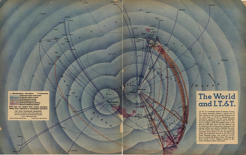
Mapping in the digital age. Janet Abrams and Peter Hall, editors Deborah Littlejohn,

Explores the ascendancy of mapping as an interdisciplinary strategy, one that connects people and places, data and organizations, and physical and virtual spaces. the book is conceptually organized into four sections that explore, in turn, the mapping ofNetworks, Conversations, Territories and Mapping itself. Each section includes critical essays, reportage, and Q&A interviews, interspersed with a "gazetteer" of full-color images.

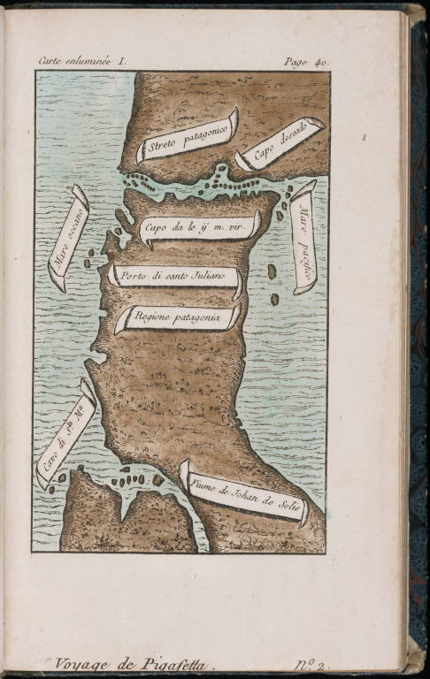
# Imagined Pilgrimage in Gothic Art: Maps, Manuscripts and Labyrinths (Matthew, Paris, England, Medieval). Connolly, Daniel Kevin. . University of Chicago. Advisor Linda Seidel. 1998. The author discusses the itinerary maps developed by Matthew Paris at the Benedictine Abbey of St. Albans, that describe pilgrimage routes and mark places of religious significance along the way. The importance of the holy land of Jerusalem to the medieval pilgrim and Christian is also discussed. These maps allowed monks to performed imagine pilgrimages to Jerusalem.

ITINERARY MAP BY MATTHEW PARIS. This shows two sections of a mid-thirteenth-century itinerary of the route to the Holy Land.

# Monumenta Cartographica Neerlandica

A series of 9 volums that aims to present an inventory of rare and significant Dutch maps and charts from the period 1550 and 1700. The bi-lingual work (Dutch and English) is the result of the author's investigations carried out during the past 30 years in numerous Dutch and foreign collections. Many maps are reproduced in full size facsimiles.

# Maps of Medieval Thought, Kline, Naomi Reed: The Hereford Paradigm, Boydell & Brewer, Woodbridge, Suffolk, 2001 . Filled with information and lore, mappae mundi present an encyclopedic panorama of the conceptual 'landscape' of the middle ages. Previously objects of study for cartographers and geographers, the value of medieval maps to scholars in other fields is now recognized and this book, written from an art historical perspective, illuminates the medieval view of the work represented in a group of maps of c.1300...

# The Self-Made Map

. Illuminates the connection between literature, identity, and mapmaking in fifteenth- and sixteenth-century France.The Self-Made Map argues that during the Renaissance in France a "new cartographic impulse" affected both the "graphic and imaginary forms of literature."

# How to Lie with Maps by Mark Monmonier.

this illustrated essay on the use and abuse of maps teaches us how to evaluate maps critically and promotes a healthy skepticism about these easy-to-manipulate models of reality. Monmonier shows that, despite their immense value, maps lie. In fact, they must.

# Graphs, Maps, Trees: Abstract Models for a Literary History by Franco Moretti

Professor Franco Moretti argues heretically that literature scholars should stop reading books and start counting, graphing, and mapping them instead. For any given period scholars focus on a select group of a mere few hundred texts: the canon. As a result, they have allowed a narrow distorting slice of history to pass for the total picture. Moretti offers bar charts, maps, and time lines instead, developing the idea of "distant reading," set forth in his path-breaking essay "Conjectures on World Literature," into a full-blown experiment in literary historiography, where the canon disappears into the larger literary system.

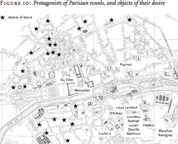
(from the "Maps" chapter) Moretti constructed his maps by hand, with the help of grad student labor; it will be interesting to see if Gutenkarte will make this sort of visualization accessible to all. photo via futureofthebook

# The Atlas of Experience by Louis van Swaaij, Jean Klare.

An illustrated guide to the most adventurous journey there is: Life. It Is a book of maps substituting the range of human experiences for mountains, rivers, plains, bridges, and ferry routes. The Atlas of Experience is a beautifully illustrated collection of maps and text depicting, as places and features on an fantasy globe, states of mind -- Elation, Panic, Loneliness, the Swamps of Sloth, and The Long Road Home. Created by two Dutch cartographers, the maps are drawn “in subjective projection and reproduced in unimaginable scale.” “Our intentions are serious,” they say, “but you can take the atlas lightly.”

# The History of Cartography, is a multi-volume History of Cartography series of research, editorial, and publishing venture drawing international attention to the history of maps and mapping. Its inter-disciplinary approach brings together scholars in the arts, sciences, and humanities. The Project encourages a broader view of maps that has significantly influenced other fields of study. The books are extensively illustrated and contain detailed footnotes, appendixes, and reference maps. (so far have completed several books) and a list of Recent Trends in the History of Cartography: A Selective, Annotated Bibliography to the English-Language Literature via maproom

# from place to PLACE: maps and Parish Maps Writings about maps and places. Sets the scene for an idea which challenges communities to explore, express and care for the things they value in their every-day places. Writers including: Barbara Bender, Robin Grove-White. Simon Lewty, Richard Mabey and Adam Nicolson, are joined by people describing their experiences of Parish Mapping. Common Ground. 1996.

Tuesday, April 10, 2007

Disaster Maps of Japan

You can feel it bleeding. Drawings of Air-raid damaged sites of major cities in Japan was prepared in December, 1945, by Records Department of First Demobilization Ministry to notify outline of Air-raid damage to repatriates. The foreword of the document mentions the importance of this survey and necessity of making quick adjustment after finding that the first question asked by repatriating military personnel and civilian employees of the military landing on Japanese shores was generally about Air-raid damage.

Friday, April 06, 2007

Smell Jars of the Stasi

For those who watched the excellent movie, 'The lives of Others', this smell jars will be familiar, yet their historic authenticity came to my knowlege only by reading this overwhelming information via kirchersociety After the fall of the Berlin Wall, many astounding revelations came to light about the Stasi, the East German secret police. One of the more bizarre activities the Stasi was found to have engaged in was the collection of Geruchsproben ( smell samples ) for the benefit of the East German smell hounds. he odors, collected during interrogations using a perforated metal “smell sample chair” or by breaking into people’s homes and stealing their dirty underwear, were stored in small glass jars. Many of the remaining East German smell jars are on display at the Stasi Museum in Berlin. via kirchersociety

Man as Industrial Palace

Illustration by Fritz Kahn.

This image, by the artist Fritz Kahn, shows the nervous system as a complex electronic signalling system, complete with buttons, charts and busy workers. Fritz Kahn's books and illustrations explored the inner machinery of the human body, using metaphors of modern industrial life. Kahn turned the brain into a complex factory with light projectors, conveyor belts, secretaries and cinema screens; he showed the journeys of blood cells as locomotives encircling the globe; and he compared bones to modern building materials such as reinforced concrete.

Der Mensch als Industriepalast (Man as Industrial Palace). image via

Kahn’s modernist visualization of the digestive and respiratory system as "industrial palace," really a chemical plant, was conceived in a period when the German chemical industry was the world’s most advanced.

Kahn was born in Halle on September 29, 1888 to Arthur Kahn and his wife Hedwig Kahn (née Schmul). He first attended school in Halle, and later the Sophien-Gymnasium in Berlin. After graduating school in 1907, Fritz Kahn studied medicine. He finished his studies completing his dissertation on Das Versehen der Schwangeren in Volksglaube und Dichtung in 1912, and started to practice as a gynecologist in Berlin. During his studies, Fritz Kahn became involved with writing articles on popular sciences. In 1920 he published a book on the Race question, Die Juden als Rasse und Kulturvolk. One of his most well-known works, Das Leben des Menschen, a five volume edition on the human body, was published between 1922 and 1932. Around 1914, Fritz Kahn served in the military during World War I. Shortly before Hitler came on power in 1933, Fritz Kahn travelled to Palestine, where he started to work on his manuscript Die Naturgeschichte Palestinas (The Natural History of Palestine). Because of the political situation in Germany, he was not able to return there. Eventually, he became a citizen of Palestine and settled in Jerusalem. In 1939, Fritz Kahn left Palestine for France and Portugal before he was able to immigrate to the United States early in 1941 with the help of Varian Fry and Albert Einstein. read on his exciting life story: http://findingaids.cjh.org/?fnm=ArthurFritzKahn&pnm=LBI

Wednesday, April 04, 2007

Picture of the Battle

a detail from Nagashino kassen no zu [military history]. from the absulutly AMAZING Kano collection of military history .

Detail of Shimabaranojin zu [military history]

The Kano Collection is the collection of Kano Kokichi (1865-1942), who is known as a Meiji era philosopher and educator. It is a source known to the world as "an encyclopedia of classic, a treasure house of Edo era studies"; the collection's items amount to no less than 108,000 across all fields, such as philosophy, art, history, literature, military science, and so on. The Kano Collection - Image database contains about 450 antique maps and about 280 illustrated books and picture scrolls (about 13,700 images in all) among microfilmed books in Japanese binding, allowing the images to be accessed via the Internet.

From the Edo period, This detailed pictures of the battle where the Edo shogunate destroys the Toyotomi family at Osaka Castle. The Battle of Osaka refers to both the winter battle in 1614 and the summer battle in 1615.

and a detail from Sekigahara Kassen Zu (The Picture of the Battle of Sekigahara):

The picture depicts the battle at Sekigahara in 1600 which would determine who should lead the Toyotomi warrior regime.

Detail from Bishuu kanie kassen no zu [military history]

Detail from Bishuu nagakute kassenzu [military history]

from Shinshuu ueda kassenzu [military history]