London: A Life in Google Maps
By reading the fascinating article City of illusions by Peter Ackroyd, i leared about this exhibition
(via 3 quark daily):
A virtual exhibition Google Map "London: a life in maps" opens at the British Library, London NW1 on the 24 November. For details, see [http://www.bl.uk/]
London: A Life in Maps charts the growth of the city by looking at maps of it through the ages. The exhibition is broken down into seven themes, each broadly covering a different period in the city's history. by going over present London google map, one is invited to travel over time and maps.
John Ogilby, ROAD MAPS. London, Ewell, Dorking, Billingshurst, Amberley, Arundel, Chichester
London was founded by the Romans in about 50 AD and acquired its walls between 190 and 225. Despite some expansion London remained essentially within these walls until 1550. The city had several generally-accepted set images at this time – particularly as a walled city and as a city on the Thames - before the creation of the standard view from Bankside dating from the 1540s. William Smith's 1588 panorama for example remains an iconic image of London. The earliest surviving printed maps of London portray a bustling, prosperous and well-ordered city. Wenceslas Hollar was completing what would have been a magnificent map when the Great Fire of 1666 intervened. But in reality there had always been more industry (and noise, discomfort, disease and smells) than was reflected in the printed maps.
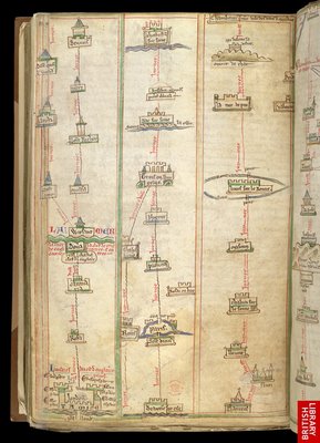
Itinerary From London To Chambery, In Matthew Paris's 'Book Of Additions' 1250-1254
The history of London may be said to unfold, map by map, in symbolic fashion. The map is a symbol, not a record or a description. It bears as much relation to the actual shape and nature of London as the sculptures of Canova or Rodin bear to the human form. The map is an idealisation, a beautiful illusion of symmetry and grace. It gives form and order to the formless and disordered appearance of the capital.
The first printed map of London has been called the "Agas map" but in fact its designer and engraver are unknown; it is believed to have been commissioned by Queen Mary to celebrate the 16th-century city over which she ruled. In its complete form, it would have measured some eight feet wide and five feet high, and was designed to encompass both the city and its suburbs beyond the walls.

a section of the Agas map


4 comments:
Incredible pictures, it is amazing how in so little amount of time, we already developed in a big society that is almost running out of places to live.
what amazing old pictures,I think that this is wonderful,I know that many times we have to improve it because the maps change every single day
More about the author gucci replica handbags like this replica bags helpful hints replica ysl bags
replica bags pakistan replica gucci bags e0q65s1y42 replica bags turkey Continue Reading c3c91s1j93 replica louis vuitton bags replica bags ebay More about the author p8e59c7e64 fake louis vuitton 9a replica bags n3z82g9q69
Post a Comment