Wish list II
New Cartographies of Networks and Territories (2 volumes) Mapping in the digital age. Janet Abrams and Peter Hall, editors Deborah Littlejohn,
Explores the ascendancy of mapping as an interdisciplinary strategy, one that connects people and places, data and organizations, and physical and virtual spaces. the book is conceptually organized into four sections that explore, in turn, the mapping ofNetworks, Conversations, Territories and Mapping itself. Each section includes critical essays, reportage, and Q&A interviews, interspersed with a "gazetteer" of full-color images.
# Imagined Pilgrimage in Gothic Art: Maps, Manuscripts and Labyrinths (Matthew, Paris, England, Medieval). Connolly, Daniel Kevin. . University of Chicago. Advisor Linda Seidel. 1998. The author discusses the itinerary maps developed by Matthew Paris at the Benedictine Abbey of St. Albans, that describe pilgrimage routes and mark places of religious significance along the way. The importance of the holy land of Jerusalem to the medieval pilgrim and Christian is also discussed. These maps allowed monks to performed imagine pilgrimages to Jerusalem.

ITINERARY MAP BY MATTHEW PARIS. This shows two sections of a mid-thirteenth-century itinerary of the route to the Holy Land.
# Monumenta Cartographica Neerlandica
A series of 9 volums that aims to present an inventory of rare and significant Dutch maps and charts from the period 1550 and 1700. The bi-lingual work (Dutch and English) is the result of the author's investigations carried out during the past 30 years in numerous Dutch and foreign collections. Many maps are reproduced in full size facsimiles.
# Maps of Medieval Thought, Kline, Naomi Reed: The Hereford Paradigm, Boydell & Brewer, Woodbridge, Suffolk, 2001 . Filled with information and lore, mappae mundi present an encyclopedic panorama of the conceptual 'landscape' of the middle ages. Previously objects of study for cartographers and geographers, the value of medieval maps to scholars in other fields is now recognized and this book, written from an art historical perspective, illuminates the medieval view of the work represented in a group of maps of c.1300...
. Illuminates the connection between literature, identity, and mapmaking in fifteenth- and sixteenth-century France.The Self-Made Map argues that during the Renaissance in France a "new cartographic impulse" affected both the "graphic and imaginary forms of literature."
# How to Lie with Maps by Mark Monmonier.
this illustrated essay on the use and abuse of maps teaches us how to evaluate maps critically and promotes a healthy skepticism about these easy-to-manipulate models of reality. Monmonier shows that, despite their immense value, maps lie. In fact, they must.
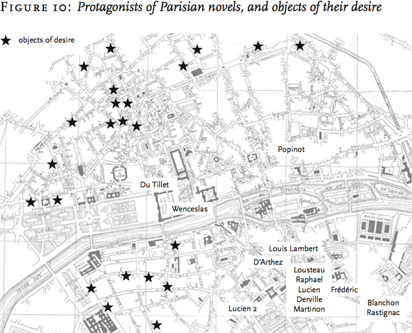
# Graphs, Maps, Trees: Abstract Models for a Literary History by Franco Moretti
Professor Franco Moretti argues heretically that literature scholars should stop reading books and start counting, graphing, and mapping them instead. For any given period scholars focus on a select group of a mere few hundred texts: the canon. As a result, they have allowed a narrow distorting slice of history to pass for the total picture. Moretti offers bar charts, maps, and time lines instead, developing the idea of "distant reading," set forth in his path-breaking essay "Conjectures on World Literature," into a full-blown experiment in literary historiography, where the canon disappears into the larger literary system.

(from the "Maps" chapter) Moretti constructed his maps by hand, with the help of grad student labor; it will be interesting to see if Gutenkarte will make this sort of visualization accessible to all. photo via futureofthebook
# The Atlas of Experience by Louis van Swaaij, Jean Klare.
An illustrated guide to the most adventurous journey there is: Life. It Is a book of maps substituting the range of human experiences for mountains, rivers, plains, bridges, and ferry routes. The Atlas of Experience is a beautifully illustrated collection of maps and text depicting, as places and features on an fantasy globe, states of mind -- Elation, Panic, Loneliness, the Swamps of Sloth, and The Long Road Home. Created by two Dutch cartographers, the maps are drawn “in subjective projection and reproduced in unimaginable scale.” “Our intentions are serious,” they say, “but you can take the atlas lightly.”
# The History of Cartography, is a multi-volume History of Cartography series of research, editorial, and publishing venture drawing international attention to the history of maps and mapping. Its inter-disciplinary approach brings together scholars in the arts, sciences, and humanities. The Project encourages a broader view of maps that has significantly influenced other fields of study. The books are extensively illustrated and contain detailed footnotes, appendixes, and reference maps. (so far have completed several books) and a list of Recent Trends in the History of Cartography: A Selective, Annotated Bibliography to the English-Language Literature via maproom
# from place to PLACE: maps and Parish Maps Writings about maps and places. Sets the scene for an idea which challenges communities to explore, express and care for the things they value in their every-day places. Writers including: Barbara Bender, Robin Grove-White. Simon Lewty, Richard Mabey and Adam Nicolson, are joined by people describing their experiences of Parish Mapping. Common Ground. 1996.


3 comments:
Moon,
The intellectual discourse of these maps is a vast terrain. I wonder if any of the monks found moral certainly on their imaginary pilgrimages?
Alas, I have made my own.
I like the fiction map and it shows that certain neighborhoods are certainly more desirable than other.
i have no doubt they did :)
Post a Comment